



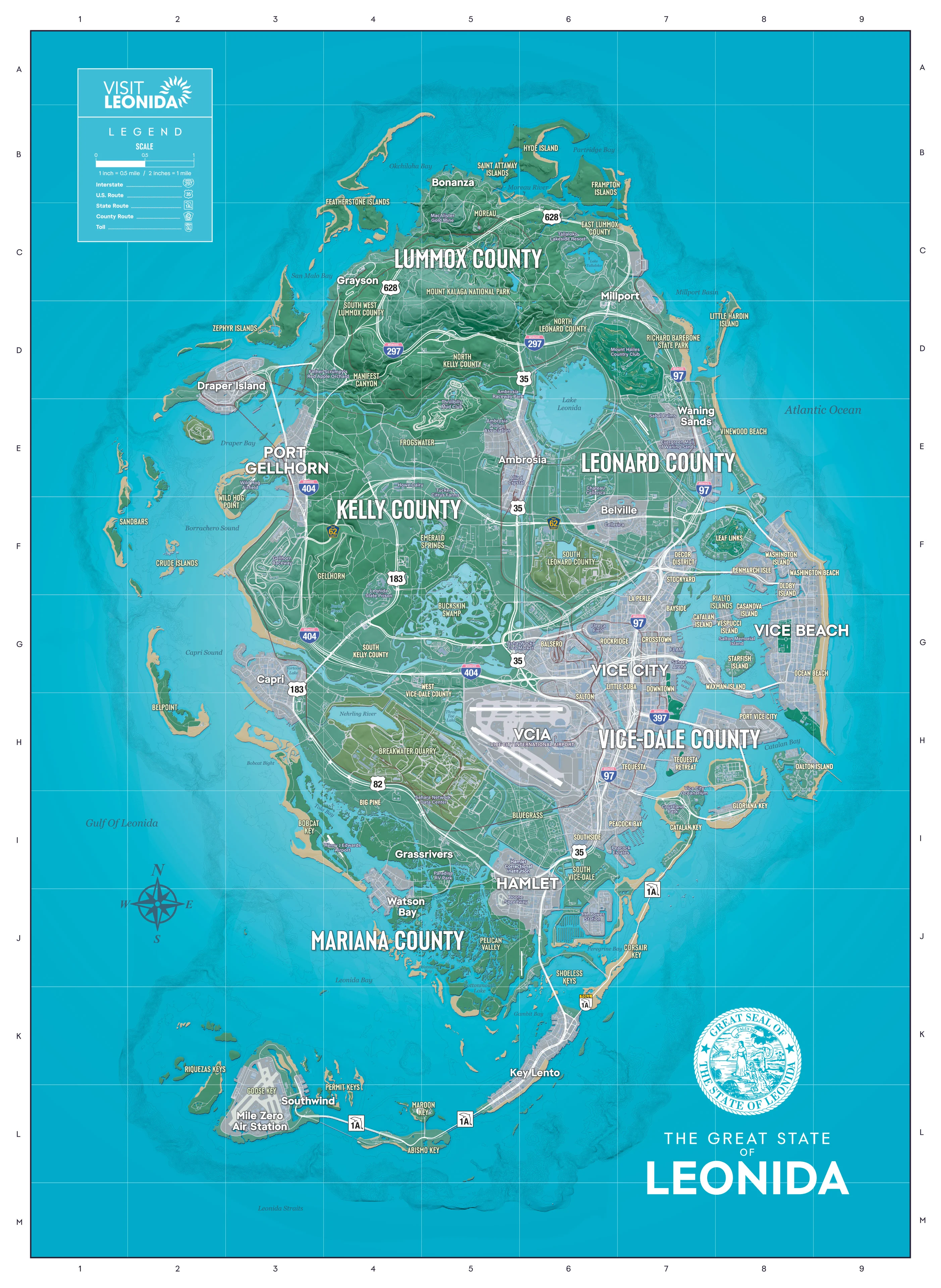
Rockstar Games published GTA 6’s official Leonida map on November 19, 2026, offering the clearest verified look yet at the fictional state’s geography. Released alongside the company’s Grand Theft Auto VI launch announcement, the map names five counties and lays out major cities, beaches, ports, roads, airports, parks, wetlands, and island chains.
Leonida is divided into Lummox, Kelly, Leonard, Vice-Dale, and Mariana counties. Vice City and Vice Beach dominate the southeastern coast, while Port Gellhorn sits on the western side of the state. The map also marks a broad interior road network, large bodies of water, rural settlements, protected parkland, and the long string of southern islands.
Vice City, Vice Beach, and Port Gellhorn anchor the map
Vice City is shown as Leonida’s densest urban center, with Downtown, Little Cuba, Rockridge, Southside, and other named districts connected by highways and bridges. The coastal strip continues through Vice Beach, where Washington Beach and Ocean Beach face the Atlantic. Port Vice City appears to the south, while the Vice City International Airport, labeled VCIA, occupies a large area immediately west of the city.
Across the state, Port Gellhorn forms another major urban and transport center on the western coast. Draper Island lies just offshore, while Wild Hog Airfield and Interstate 404 appear nearby. Other named population centers include Millport, Waning Sands, Belleville, Ambrosia, Capri, Hamlet, Bonanza, Grassrivers, and Watson Bay.
Highways, airports, parks, and islands show Leonida’s variety
The road map links the five counties through several interstate and regional routes. Interstates 97, 297, 397, and 404 cross the state alongside U.S. Routes 35 and 82, Route 183, and State Route 1A. The network includes dense city junctions around Vice City, long north-south corridors, coastal roads, and bridges leading into the southern keys.
Aviation is represented by more than VCIA. The map also names Henry J Edwards Airport in the southwest, Mile Zero Air Station on the southern islands, and Wild Hog Airfield near Port Gellhorn. These sites sit alongside ports and coastal communities, emphasizing how much of Leonida’s geography is shaped by water.
Inland, Mount Kalaga National Park occupies a large part of Lummox County, while Richard Barebone State Park appears along the eastern side of the map. Lake Leonida, Buckskin Swamp, Grassrivers, rivers, bays, agricultural areas, and scattered small towns separate the biggest cities. Farther south, the Shoeless Keys, Riquezas Keys, Key Lento, and other islands extend into the Leonida Straits.
Taken together, the official map presents a state that moves from dense urban districts and beach communities to industrial ports, inland highways, parkland, wetlands, rural areas, and offshore islands. It does not establish the game world’s size or confirm what activities take place in any location, so the map’s verified value is in its geography rather than unannounced gameplay details.
For confirmed release and platform information, see our GTA 6 release date, price, platforms, and PC version guide.
Featured image credit: Game News Plus; GTA 6 and Leonida map imagery © Rockstar Games.
Which part of Leonida will you explore first?



Comments
No comments yet. Be the first to share your thoughts.